
As millions wait for the arrival of the southwest monsoon, the latest satellite images from space are showing encouraging signs that rain-bearing clouds are finally beginning to gather strength over India.
Fresh imagery from the INSAT-3DS weather satellite on Wednesday revealed expanding cloud cover across large parts of the country, from the Himalayas to the southern peninsula, highlighting an increasingly active atmosphere as the monsoon inches closer.
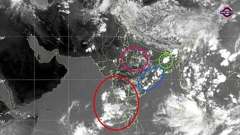
One of the most noticeable features in the image is a vast swath of cloud stretching across northern India and adjoining Pakistan. Dense thunderstorm clouds are visible over Jammu & Kashmir, Himachal Pradesh and Uttarakhand, while scattered convective activity extends into Punjab, Haryana and Uttar Pradesh.
The cloud build-up is also evident over eastern India. Large clusters of thunderstorms can be seen from Odisha and West Bengal to the northeastern states, where moisture from the Bay of Bengal continues to fuel daily rainfall and lightning activity.
Further south, meteorologists are closely monitoring developments near Kerala. Satellite imagery shows growing cloud masses over the southeastern Arabian Sea and along India's southwest coast, where a mid-level cyclonic circulation is helping draw moisture inland.
Weather experts say this feature is likely to enhance rainfall over Kerala and coastal Karnataka during the next few days while creating conditions favourable for the onset of the southwest monsoon.
The image also highlights vigorous cloud development over the eastern Bay of Bengal and the Andaman Sea. These tropical cloud clusters are important because they help strengthen the large-scale monsoon circulation that eventually spreads rain across the Indian subcontinent.
The increasing cloud cover comes after several days of widespread thunderstorms across north, central and eastern India that brought temporary relief from intense summer heat. Many locations witnessed sharp temperature drops as thunderstorms, gusty winds and rain swept across the region.
Looking ahead, forecasters expect thunderstorm activity to remain widespread over much of the country, while rainfall is likely to increase over Kerala, Karnataka and parts of Tamil Nadu. If current trends continue, the southwest monsoon could officially establish itself over Kerala on June 4.
For now, the satellite images tell a clear story: after weeks of waiting, the atmosphere is becoming increasingly active, and the first signs of India's rainy season are beginning to take shape from space.